| RELATED INFO |
| * Eric Calais |
| * Supplemental information |

March 13, 2009
New Madrid fault system may be shutting down
WEST LAFAYETTE, Ind. - |
A team from Purdue and Northwestern universities analyzed the fault motion for eight years using global positioning system measurements and found that it is much less than expected given the 500- to 1,000-year repeat cycle for major earthquakes on that fault. The last large earthquakes in the New Madrid seismic zone were magnitude 7-7.5 events in 1811 and 1812.
Estimating an accurate earthquake threat for the area, which includes parts of Illinois, Indiana, Tennessee, Arkansas and Kentucky, is crucial for the communities potentially affected, said Eric Calais, the Purdue researcher who led the study.
"Our findings suggest the steady-state model of quasi-cyclical earthquakes that works well for faults at the boundaries of tectonic plates, such as the San Andreas fault, does not apply to the New Madrid fault," said Calais, who is a professor of earth and atmospheric sciences. "At plate boundaries, faults move at a rate that is consistent with the rate of earthquakes so that past events are a reliable guide to the future. In continents, this does not work. The past is not necessarily a key to the future, which makes estimating earthquake hazard particularly difficult."
The team determined that the ground surrounding the fault system is moving at a rate of less than 0.2 millimeters per year and there is likely no motion. A paper detailing the work is published in the current issue of Science magazine.
Seth Stein, co-author of the paper, said this surface movement represents energy being stored that could be released as an earthquake.
"Building up energy for an earthquake is like saving money for a big purchase," said Stein, the William Deering Professor of Earth and Planetary Sciences at Northwestern University. "You put money in over a long period of time and then spend it all at once and have to start saving again."
With an earthquake, it is elastic deformation that must be built up. This can be measured using GPS through movements on the surface, he said.
"The slower the ground moves, the longer it takes until the next earthquake, and if it stops moving, the fault could be shutting down," Stein said. "We can't tell whether the recent cluster of big earthquakes in the New Madrid is coming to an end. But the longer the GPS data keep showing no motion, the more likely it seems."
The U.S. Geological Survey-funded study used data recorded at nine GPS antennas mounted in the ground in the earthquake zone.
"GPS technology can measure movement to the thickness of a fishing line," Stein said. "Use of GPS to study earthquakes shows the impact a new technology can have. It lets us see that the world is different than we thought it was."
In the Midwest there are other faults that show no activity today but have evidence of earthquakes occurring within the past 10,000 to 1 million years, Calais said.
"If other faults in the central and eastern U.S. have been active recently, geologically speaking, they could potentially be activated again in the future," he said. "We need to develop a new paradigm for how earthquakes happen at faults that are inside continents."
Calais and Stein are exploring possible explanations for the behavior of faults like the New Madrid. One possibility is that earthquakes in these areas occur in clusters and then migrate to a nearby fault.
"There is the possibility that seismicity migrates with time as earthquakes trigger earthquakes on nearby faults," Calais said. "Geologists studying the seismic history of faults have found that there have been earthquakes on several faults in the central and eastern U.S. and that they seem to produce bursts of earthquakes and then turn off."
The team is doing additional analysis and modeling to study this further.
Writer: Elizabeth K. Gardner, 765-494-2081, ekgardner@purdue.edu
Sources: Eric Calais, 765-409-5134, ecalais@purdue.edu
Seth Stein, 847-491-5265, seth@earth.northwestern.edu
Purdue News Service: (765) 494-2096; purduenews@purdue.edu
IMAGE CAPTION:
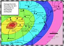
This map shows areas damaged by the Dec. 16, 1811, magnitude 7.2 earthquake. That earthquake was the first of three major temblors along the New Madrid fault in 1811 and 1812. (Image courtesy of Seth Stein, based on results by Susan Hough)
A publication-quality photo is available at https://www.purdue.edu/uns/images/+2009/earthquake-damage.jpg
Time-Variable Deformation in the
New Madrid Seismic Zone
E. Calais and S. Stein
New geodetic measurements show that the New Madrid is currently deforming too slowly - if at all - to account for large earthquakes in the region over the past 5,000 years. This, together with increasing evidence for temporal clustering and spatial migration of earthquake sequences in continental interiors, indicates that either tectonic loading rates or fault properties vary over a few thousand years.
To the News Service home page
