| RELATED INFO |
| * Eric Calais Natron project |
| * Eric Calais |
| RELATED NEWS RELEASE |
| * New data shakes accepted models of collisions of the Earth's crust |

December 10, 2008
Team led by Purdue professor first to record key event that breaks continents apart
WEST LAFAYETTE, Ind. - |
An international research team led by Eric Calais, a Purdue University professor of geophysics, was able to measure ground displacements as two tectonic plates in Africa moved apart and molten rock pushed its way toward the surface during the first so-called "dyking event" ever recorded within the planet's continental crust.
The event left a wall of magma 6 miles long and 5 feet wide wedged between the two plates. A paper detailing the event will be published Wednesday (Dec. 11) in Nature.
Dyking events have been reported in the thin oceanic crust but had never been directly observed and quantified in the thicker areas of the planet's shell, Calais said.
 |
"Such dyking events had been included in theories, but researchers had never before been in the right place at the right time with the right equipment to record them," Calais said. "The event was preceded by a slow slipping of the tectonic plates along a fault line. This also had not been seen before. Faults usually slip suddenly, which produces earthquakes, but this was a very seismically quiet course of events that lasted about one week."
The existence of these events provides a key element of how the Earth's rigid outer shell - the lithosphere - breaks apart and moves. The known forces pushing and pulling on continents are not powerful enough to break them apart. However, repeated dyking events could weaken the lithosphere severalfold, allowing it to shift and break under far less force, Calais said.
"To break a continent apart, one needs to overcome the strength of the Earth's lithosphere," he said. "But when we calculate the forces available from plate tectonics, we find that they are not large enough to do the job. We know that continents break apart and have done so repeatedly in the geological past. So, how can it happen? One way is to add a little push to the system, and this is exactly what dyke intrusions do."
During a dyke intrusion, magma held in deep reservoirs breaks through surrounding rock and rises toward the surface, forcing the two plates apart, and, over time, weakening the lithosphere by transferring heat to the surrounding rocks. The magma fills and widens cracks and fractures as it rises. The end result is a vertical wall, or dyke, of magma that has pushed the Earth's crust apart, he said.
"Eventually, if these events occur over and over again for millions of years, an ocean will form between the two plates," he said. "So, today in Tanzania, we are really witnessing the earliest stages of ocean formation."
Calais and his collaborators captured this event in Tanzania's Lake Natron basin during the summer of 2007. The basin lies near the southern tip of the eastern branch of the East African Rift, the area where the Somalia and Nubia tectonic plates are moving apart.
Reports of a series of moderate earthquakes from northern Tanzania felt all the way to Nairobi in Kenya caught the team's attention. French collaborators had installed seismographs in the vicinity of the Natron basin a few months before the event and recorded more than 600 small earthquakes in two weeks, pinpointing the center of the tectonic activity. Tanzanian researchers were able to collect Global Positioning System (GPS) measurements in the Natron area. Calais compared these measurements with those taken earlier to determine the amount of displacement of the Earth's surface. But these displacements did not match what was expected from the earthquakes.
"The displacement was much too large given the small size of the earthquakes, which was the first lead that something unusual was happening," Calais said. "Soon after these earthquakes, one of the volcanoes in the area entered an explosive eruptive stage, which indicated that magma was involved. So we had an idea this might be a dyking event."
He then worked with colleagues in Luxembourg to obtain radar interferometry (InSAR) data, which provided a detailed picture of ground movements. A team of led by Belgium scientists went to the area for a field check and mapped 13 miles of open fissures that corresponded well with the observations from InSAR data.
"Once we had all of the measurements, in particular the InSAR data, we knew that the combined dataset could only be explained by the injection of a dyke," Calais said. "If we had only the GPS data and/or seismic activity data, this would have been difficult to prove. We needed all of these methods to really understand what was happening."
A dyking event is mostly an aseismic process, meaning it does not create large earthquakes or release a lot of ground-shaking energy. It would be easy to miss such an occurrence without some of the advanced geodetic measurement technology available today, he said.
"When you look at events like this with only one measurement tool, you are half blind," Calais said. "You are missing a lot of what the planet is telling us. Sometimes it whispers instead of shouting."
It is possible that there have been several dyking events on the East African Rift within the past few decades, he said.
"If there is evidence that these events have been happening within recent time, there is no reason not to believe that they have been happening for several million years," Calais said. "This could then be a very important contribution to the dynamics of the East African Rift system."
Co-authors of the paper include Nicolas d'Oreye and Anneleen Oyen from the National Museum of Natural History in Luxembourg; Julie Albaric, Jacques Déverchère and Julie Perrot from the University of Brest in France; Anne Deschamps from the National Center for Scientific Research in France; Damien Delvaux, Francois Kervyn, Benoit Smets and Christelle Wauthier from the Royal Museum for Central Africa in Belgium; Cynthia Ebinger from the University of Rochester; Richard W. Ferdinand from the University of Dar es Salaam in Tanzania; Athanas S. Macheyeki from the Renard Centre of Marine Geology in Belgium; Elifuraha Saria from Ardhi University in Tanzania; and D. Sarah Stamps from Purdue.
Calais and his collaborators next will watch the surrounding area for the aftermath of this dyking event.
"When a large event like this occurs, the state of stress on the Earth's upper layers are changed, and we expect several additional events to follow," Calais said. "Other magma reservoirs may be touched and trigger another dyking event. It will take a while for the system to relax again and get back to its quiet, steady-state, behavior."
His team also plans to examine the area in more detail to try to discover evidence of past dyking events. This information could illustrate any historical patterns in the incidences of these events and how regularly they occur.
"At stake is a better understanding of geohazards in East African countries, whose fragile economy may easily be disrupted even by seismic or volcanic events of moderate magnitude," Calais said.
The National Science Foundation funded this research.
Writer: Elizabeth K. Gardner, (765) 494-2081, ekgardner@purdue.edu
Source: Eric Calais, (765) 496-2915, ecalais@purdue.edu
Purdue News Service: (765) 494-2096; purduenews@purdue.edu
PHOTO CAPTION:
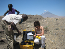
Purdue University graduate student Sarah D. Stamps and Tanzanian scientist Elifuraha Saria install a Global Positioning System instrument in the Natron area of Tanzania. The Ol Doinyo Lenga volcano is visible in the background. Global Positioning Systems were used by a Purdue-led team to capture the first dyking event ever recorded within the Earth's continental crust. (Photo courtesy of Eric Calais)
A publication-quality photo is available at https://www.purdue.edu/uns/images/+2008/dyking-research.jpg
PHOTO CAPTION:
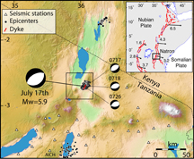
This image shows a map of the 2007 earthquakes and dyking event in Tanzania. The black circles indicate earthquakes, and the red line shows the location of the dyke intrusion. (Purdue University image/Calais laboratory)
A publication-quality photo is available at https://www.purdue.edu/uns/images/+2008/dyking-research-graphic.jpg
Aseismic Strain Accommodation by Slow Slip and Dyking in a Youthful Continental Rift, East Africa
Eric Calais, Nicolas d'Oreye, Julie Albaric, Anne Deschamps,
Damien Delvaux, Jacques Diverter, Cynthia Ebinger,
Richard W. Ferdinand, Francois Kervyn,
Athanas S. Macheyeki, Anneleen Oyen, Julie Perrot, Elifuraha Saria, Benoit Smets, D. Sarah Stamps
& Christelle Wauthier
Continental rifts initiate and develop through repeated episodes of faulting and magmatism, yet strain partitioning between faulting and magmatism during discrete rifting episodes remains poorly documented. In highly evolved rifts, tensile stresses from far-field plate motions accumulate over decades before being released during relatively short time intervals by faulting and magmatic intrusions. These rifting crises are rarely observed in thick lithosphere during the initial stages of rifting. Here we show that most of the strain during the July-August 2007 seismic crisis in the weakly extended Natron rift, Tanzania, was released aseimically. Deformation was achieved by slow slip on a normal fault that promoted subsequent dyke intrusion by stress unclamping. This event provides compelling evidence for strain accommodation by magma intrusion, in addition to slip along normal faults, during the initial stages of continental rifting, and prior to significant crustal thinning.
To the News Service home page
